Garmin eTrex H
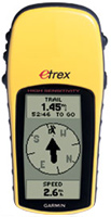 | Outdated Product £26.99 This solution is for tourists, travelers, hunters and fishermen. The navigator is able to determine the location very quickly and very accurately, regardless of weather conditions or the surrounding area (tree crowns, ravines, high-rise buildings will not be too serious a problem for him). Supports WAAS technology, which improves positioning accuracy. The monochrome screen does not fade even in very bright sunlight. Runs on regular AA batteries and is independent of charging. |
Garmin eTrex H
Type:handheld
Screen size:2.4 "
Resolution:160х240 px
Power supply:non chargeable battery
Working hours:up to 17 h
Weight:150 g
This solution is for tourists, travelers, hunters and fishermen. The navigator is able to determine the location very quickly and very accurately, regardless of weather conditions or the surrounding area (tree crowns, ravines, high-rise buildings will not be too serious a problem for him). Supports WAAS technology, which improves positioning accuracy. The monochrome screen does not fade even in very bright sunlight. Runs on regular AA batteries and is independent of charging.
All specifications
Specifications eTrex H
|
| |||||||||||||||||||||||||||||||||||||||||||||||||||||
Information in model description is for reference purposes.
Before buying always check characteristics and configuration of product with online store manager
Catalog Garmin 2025 - new products, best sales and most actual models Garmin.
Before buying always check characteristics and configuration of product with online store manager
Catalog Garmin 2025 - new products, best sales and most actual models Garmin.
Additional features sat nav Garmin eTrex H:
The Garmin eTrex H includes a GPS receiver that provides fast satellite signal acquisition and highly accurate positioning, even in challenging environments. This navigator combines an intuitive user interface, rugged housing, compact size and low weight.
Thanks to its highly sensitive WAAS-enabled GPS receiver, the device provides fast satellite signal acquisition and accurate positioning even under dense canopy and in deep ravines. You can rely on the reliable eTrex H navigator whether you are in dense forest or in a city with a lot of tall buildings.
A convenient 5-button keypad on the sides of the instrument allows you to control your eTrex H with one hand. With a bright yellow exterior, the eTrex H is easy to find on board a boat or in a backpack. The case of the device is waterproof according to the IPX7 standard, so the device is not afraid of splashes and even accidental drops in water.
The eTrex H uses two AA batteries that provide up to 17 hours of operation. Up to 500 waypoints can be stored in the instrument's memory.
Good to know:
WAAS technology
WAAS (Wide Area Augmentation System) is a system designed to increase the accuracy of satellite navigation instruments. The principle of operation of the system is based on the correction of satellite data using special corrections, which are calculated by base stations installed in the service area of the system.
- WAAS technology
- Communication with a computer via COM port
- Possibility to update the firmware
- Hunter/fisher calendar
- Sunrise/sunset and moon phase information
- Strap
- Brief instruction
- User guide
The Garmin eTrex H includes a GPS receiver that provides fast satellite signal acquisition and highly accurate positioning, even in challenging environments. This navigator combines an intuitive user interface, rugged housing, compact size and low weight.
Thanks to its highly sensitive WAAS-enabled GPS receiver, the device provides fast satellite signal acquisition and accurate positioning even under dense canopy and in deep ravines. You can rely on the reliable eTrex H navigator whether you are in dense forest or in a city with a lot of tall buildings.
A convenient 5-button keypad on the sides of the instrument allows you to control your eTrex H with one hand. With a bright yellow exterior, the eTrex H is easy to find on board a boat or in a backpack. The case of the device is waterproof according to the IPX7 standard, so the device is not afraid of splashes and even accidental drops in water.
The eTrex H uses two AA batteries that provide up to 17 hours of operation. Up to 500 waypoints can be stored in the instrument's memory.
Good to know:
WAAS technology
WAAS (Wide Area Augmentation System) is a system designed to increase the accuracy of satellite navigation instruments. The principle of operation of the system is based on the correction of satellite data using special corrections, which are calculated by base stations installed in the service area of the system.
We recommendCompare using chart →


