Garmin eTrex Vista
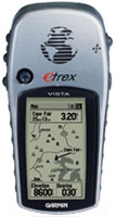 | Outdated Product £316.82 Compact GPS navigator with WAAS technology support. Thanks to this solution, the accuracy of positioning on the ground has been significantly improved. To connect to a computer, it is proposed to use the COM port. In the internal memory of the device, its size is 24 MB, through this port you can download the currently needed maps of the area and update the firmware. The 12-channel GPS signal receiver quickly finds and holds satellites. |
Garmin eTrex Vista
Type:handheld
Screen size:2.4 "
Resolution:160x105 px
Power supply:non chargeable battery
Working hours:up to 12 h
Weight:150 g
Compact GPS navigator with WAAS technology support. Thanks to this solution, the accuracy of positioning on the ground has been significantly improved. To connect to a computer, it is proposed to use the COM port. In the internal memory of the device, its size is 24 MB, through this port you can download the currently needed maps of the area and update the firmware. The 12-channel GPS signal receiver quickly finds and holds satellites.
All specifications
Specifications eTrex Vista
|
| |||||||||||||||||||||||||||||||||||||||||||||||||||
The information in the model description is for reference purposes.
Always clarify the specifications and configuration of the product with the online store manager before purchasing.
Catalog Garmin 2025 - new arrivals, bestsellers, and the most relevant models Garmin.
Always clarify the specifications and configuration of the product with the online store manager before purchasing.
Catalog Garmin 2025 - new arrivals, bestsellers, and the most relevant models Garmin.
Additional features sat nav Garmin eTrex Vista:
The Garmin eTrex Vista includes a complete base map of America, Europe, or Australia, a barometric altimeter, an electronic compass, and 24MB of internal storage for additional data. A built-in barometric altimeter provides accurate altitude calculations, while an electronic compass is used to provide bearing information (data is available even if the device is stationary).
In addition, the eTrex Vista can accept WAAS corrections to improve accuracy. When using the WAAS function, the accuracy of the location calculation is increased to 3 metres.
The eTrex Vista basemap contains lakes, rivers, cities, highways, highways, railroads, and coastlines. Also, the device comes loaded with information about marine navigational objects. Using the instrument's 24 MB of internal memory, additional Garmin MapSource maps can be added.
Good to know:
WAAS technology
WAAS (Wide Area Augmentation System) is a system designed to increase the accuracy of satellite navigation instruments. The principle of operation of the system is based on the correction of satellite data using special corrections, which are calculated by base stations installed in the service area of the system.
- WAAS technology
- Possibility to update the firmware
- Communication with a computer via a serial COM port
- Strap
- Computer interface cable
- Brief instruction
- User guide
- eTrex Vista — Monochrome Display, 20 Routes, 1000 Waypoints, No Auto Route Calculation, No Memory Card Slot, No USB Interface
- eTrex Vista Cx — Colour Display, 50 Routes, 500 Waypoints, Auto Route Calculation, Memory Card Slot, USB Interface
The Garmin eTrex Vista includes a complete base map of America, Europe, or Australia, a barometric altimeter, an electronic compass, and 24MB of internal storage for additional data. A built-in barometric altimeter provides accurate altitude calculations, while an electronic compass is used to provide bearing information (data is available even if the device is stationary).
In addition, the eTrex Vista can accept WAAS corrections to improve accuracy. When using the WAAS function, the accuracy of the location calculation is increased to 3 metres.
The eTrex Vista basemap contains lakes, rivers, cities, highways, highways, railroads, and coastlines. Also, the device comes loaded with information about marine navigational objects. Using the instrument's 24 MB of internal memory, additional Garmin MapSource maps can be added.
Good to know:
WAAS technology
WAAS (Wide Area Augmentation System) is a system designed to increase the accuracy of satellite navigation instruments. The principle of operation of the system is based on the correction of satellite data using special corrections, which are calculated by base stations installed in the service area of the system.


