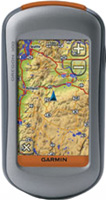
Garmin Oregon 300
 | Outdated Product Application area: handheld; Water protection; Number of routes: 50; Waypoints: 1000; Navigation features: Bands number: 12; screen size ("): 3; resolution (px): 400х240; USB; memory card slot; Battery life (h): 16; Dimensions (mm): 114x58x35; Weight (g): 193; |
We recommend products in stockSat Navs Garmin →
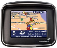


motorcycle, 3.4 ", memory 16 GB, Live Traffic, Wi-Fi, water protection IPX7, up to 6 hours of work, 280 g
handheld, 3 ", memory 4 GB, Wi-Fi, ANT+, water protection IPX7, up to 40 hours of work, 272 g
handheld, 3 ", memory 8 GB, water protection IPX7, non chargeable batteries, up to 19 hours of work, 282 g


handheld, 3 ", memory 16 GB, Wi-Fi, ANT+, water protection IPX7, up to 180 hours of work, 230 g
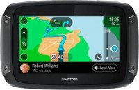
motorcycle, 3.4 ", memory 16 GB, map update, Live Traffic, Wi-Fi, water protection IPX7, up to 6 hours of work, 280 g

handheld, 4 ", memory 4 GB, camera, water protection IPX7, up to 16 hours of work, 333 g
handheld, 3 ", memory 16 GB, Wi-Fi, ANT+, water protection IPX7, up to 180 hours of work, 230 g

handheld, 3.5 ", memory 16 GB, Wi-Fi, ANT+, water protection IPX7, up to 55 hours of work, 280 g
handheld, 3.5 ", memory 16 GB, Wi-Fi, ANT+, water protection IPX7, up to 55 hours of work, 280 g
Garmin Oregon 300
Type:handheld
Screen size:3 "
Resolution:400х240 px
Working hours:up to 16 h
Weight:193 g
All specifications
Specifications Oregon 300
|
| |||||||||||||||||||||||||||||||||||||||||||||||||||||||||||
The information in the model description is for reference purposes.
Always clarify the specifications and configuration of the product with the online store manager before purchasing.
Catalog Garmin 2026 - new arrivals, bestsellers, and the most relevant models Garmin.
Always clarify the specifications and configuration of the product with the online store manager before purchasing.
Catalog Garmin 2026 - new arrivals, bestsellers, and the most relevant models Garmin.
Additional features sat nav Garmin Oregon 300:
The Garmin Oregon 300 is a handheld GPS receiver with a touchscreen display, magnetic compass and barometric altimeter. Oregon 300 can be used in adverse weather conditions, and therefore meets the standards of water resistance and shock resistance.
Easy to operate and easy to use, this device is equipped with a high-performance GPS chipset, a 3-inch high-resolution touch screen display, which allows you to control the device with a flick of your fingers. HotFix technology automatically calculates and stores information about the position of the satellites and allows you to calculate the coordinates much faster.
The Oregon 300 has a barometric altimeter and an electronic compass. As additional accessories, you can connect a wireless heart rate sensor, a cadence sensor to the Oregon series navigator. Garmin Oregon series software is compatible with older device applications — the user will be able to transfer all maps, routes and geotagging to Garmin Oregon 200 and 300. Garmin Oregon navigators support 3D terrain maps and maps in g2 vision format.
Good to know:
WAAS technology
WAAS (Wide Area Augmentation System) is a system designed to increase the accuracy of satellite navigation instruments. The principle of operation of the system is based on the correction of satellite data using special corrections, which are calculated by base stations installed in the service area of the system.
- WAAS technology
- Hunter/fisher calendar
- Sunrise/sunset and moon phase information
- Built-in GPS games
- Area calculation
- Clip for fastening
- USB cable
- User manual on CD
- Garmin Oregon 200 — built-in memory — 24 MB, no built-in electronic compass, barometric altimeter (altimeter)
- Garmin Oregon 300 — built-in memory — 850 MB, built-in electronic compass, barometric altimeter (altimeter)
The Garmin Oregon 300 is a handheld GPS receiver with a touchscreen display, magnetic compass and barometric altimeter. Oregon 300 can be used in adverse weather conditions, and therefore meets the standards of water resistance and shock resistance.
Easy to operate and easy to use, this device is equipped with a high-performance GPS chipset, a 3-inch high-resolution touch screen display, which allows you to control the device with a flick of your fingers. HotFix technology automatically calculates and stores information about the position of the satellites and allows you to calculate the coordinates much faster.
The Oregon 300 has a barometric altimeter and an electronic compass. As additional accessories, you can connect a wireless heart rate sensor, a cadence sensor to the Oregon series navigator. Garmin Oregon series software is compatible with older device applications — the user will be able to transfer all maps, routes and geotagging to Garmin Oregon 200 and 300. Garmin Oregon navigators support 3D terrain maps and maps in g2 vision format.
Good to know:
WAAS technology
WAAS (Wide Area Augmentation System) is a system designed to increase the accuracy of satellite navigation instruments. The principle of operation of the system is based on the correction of satellite data using special corrections, which are calculated by base stations installed in the service area of the system.