Garmin Eu723l Mar Mediterraneo Marine Charts 5602207
 | Compare prices 2 → When you make a purchase through links on our site, we may receive a affiliate commission.
|
Buy Garmin Eu723l Mar Mediterraneo Marine Charts 5602207
When you make a purchase through links on our site, we may receive a affiliate commission.
Garmin Eu723l Mar Mediterraneo Marine Charts 5602207 | £361.99 | ||||
| £409.99 | |||||
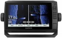
GARMIN EU723L Mar Mediterraneo Marine ChartsExperience unparalleled navigational clarity and confidence across the vast expanse of the Mediterranean with the GARMIN EU723L Mar Mediterraneo Marine Charts. This advanced cartography from the Electronics category is specifically engineered for mariners who demand the highest level of precision and detail. Transform your compatible Garmin chartplotter into a powerful navigational tool, providing a superior level of situational awareness whether you are cruising coastal waters, planning long-distance passages, or seeking out the best fishing grounds. This cartography is your essential partner for safe and efficient exploration of the Mediterranean Sea.Unlock a suite of sophisticated features designed to enhance every aspect of your journey. With data-rich overlays and cutting-edge technology, you gain a deeper understanding of your surroundings, both above and below the water.Key Features:Advanced Auto Guidance TechnologyEffortlessly plan your voyages with state-of-the-art routing. This technology uses your vessel´s dimensions and detailed chart data to automatically calculate a suggested path to your destination, helping you navigate around known obstacles, shallow waters, and other potential hazards.High-Detail Bathymetric ContoursGain a superior understanding of the seabed with incredible precision. The charts provide a highly detailed and accurate image of the bottom structure, which is critical for safe anchoring, identifying fishing spots, and navigating complex underwater topography.Customizable Depth Range ShadingQuickly identify target depths at a single glance. This powerful function allows you to highlight up to ten user-defined depth ranges, each with a unique color. This makes it exceptionally easy to spot safe navigational channels, ideal anchoring depths, or specific contours for fishing.Dedicated Fishing ChartsElevate your angling experience with specialized cartography. The fishing map offers an even more detailed and accurate reconstruction of the seabed, providing high-definition bathymetric information. This is an invaluable asset for serious fishermen looking to locate underwater ledges, drop-offs, and other fish-holding structures throughout the Mediterranean.Comprehensive Port & Tides InformationNavigate into unfamiliar harbors and marinas with enhanced certainty. Access crucial information on local tides and currents directly on your display. The charts also provide detailed indications on ports and the services available within marinas, helping you plan your arrivals and departures with greater precision.Large eu723l mediterranean sea.Auto guidance 3.0 automatically calculates the best route to reach the desired destination.Use the cartographic data to automatically process the best route to reach the set destination avoiding any obstacle along the navigation.Information on tides and currents, indications on ports and services within the marinas.Bathymetric with detail every
The product description is generated based on data from online stores. Before purchasing be sure to verify all information directly with the seller.
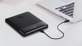
Best Power Banks with Power Delivery for Charging LaptopsCapacious batteries with support for fast charging Power Delivery, which are capable of charging laptops.
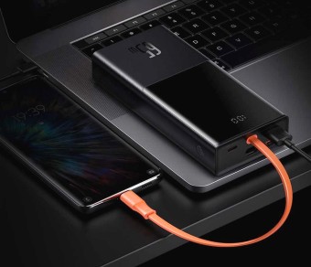
Best 20,000 mAh Power Banks with Fast ChargingPower banks that will quickly and recharge your mobile devices.
How to place an order?How to add store?
Remember that the online store is responsible for the accuracy of information regarding price, warranty, and delivery!
We recommendCompare using chart →
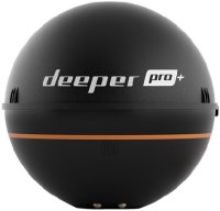
fish finder, up to 80 m, radiation: 70 °, frequencies: 2, rays: 2, wireless sensor, Wi-Fi
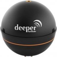
fish finder, up to 50 m, radiation: 40 °, frequencies: 1, rays: 1, wireless sensor, Wi-Fi
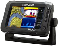
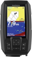
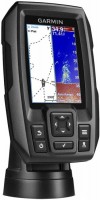
fish finder-chartplotter, colour, up to 1524 m, radiation: 120 °, frequencies: 6, rays: 2, GPS
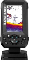
fish finder-chartplotter, colour, up to 274 m, frequencies: 6, rays: 3, GPS, 3D maps, Wi-Fi
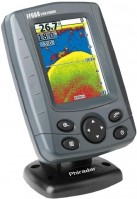
fish finder-chartplotter, colour, up to 450 m, radiation: 180 °, frequencies: 3, rays: 2, GPS

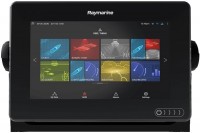
fish finder-chartplotter, colour, up to 1524 m, radiation: 180 °, frequencies: 5, rays: 6, GPS, Wi-Fi
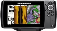
fish finder-chartplotter, colour, up to 580 m, radiation: 120 °, frequencies: 3, rays: 2, GPS