Navionics Plus Mexico-caribbean-brazil Marine Chart 155-010C136430
 | Compare prices 2 → When you make a purchase through links on our site, we may receive a affiliate commission.
|
Buy Navionics Plus Mexico-caribbean-brazil Marine Chart 155-010C136430
When you make a purchase through links on our site, we may receive a affiliate commission.
Navionics Plus Mexico-caribbean-brazil Marine Chart 155-010C136430 | £193.99 | ||||
MEXICO CARIBBEAN TO BRAZIL | £320.99 | ||||
NAVIONICS Plus Mexico-Caribbean-Brazil Marine ChartNavigate the vibrant waters of Mexico, the Caribbean, and Brazil with unparalleled confidence and detail using the NAVIONICS Plus marine chart. This all-in-one cartography solution is engineered for boaters, anglers, and sailors who demand the most accurate and up-to-date information for their GPS chartplotter. Covering an extensive portion of the Americas, from the Gulf of Mexico and the entire Caribbean archipelago down to the vast coastline of South America, this comprehensive chart card provides everything you need for safer and more successful journeys on the water.Experience a new level of situational awareness with detailed charts that go far beyond standard navigation. Whether you are exploring coastal inlets, planning an offshore passage, or seeking out the best fishing spots, NAVIONICS Plus delivers the critical data you need right at your fingertips. Enhance your fishing expeditions by identifying underwater structures, drop-offs, and ledges with high-definition bathymetry, and navigate complex channels and busy harbors with ease using intelligent routing features.Main Features:* Nautical Chart: A robust and comprehensive charting resource trusted by boaters worldwide, providing port plans, depth contours, navaids, and coastal data.* SonarChart™ HD Bathymetry: An exclusive high-definition bathymetry map featuring extraordinary bottom contour detail, with up to 1 ft (0.5 m) contours, perfect for locating fishing areas and improving navigation in shallow waters.* Community Edits: Benefit from localized chart data contributed by millions of fellow Navionics app users, adding a layer of real-time, on-the-water knowledge.* Daily Updates: Access up to 5.000 updates to your charts every day, ensuring you have the most current information on buoys, hazards, channel markers, and more for one full year.* SonarChart™ Live: Create your own personal 1 ft (0.5 m) HD bathymetry maps in real-time on your chartplotter screen as you travel across the water.* Advanced Map Options: Customize your chart view by highlighting shallow areas, adjusting contour density, and targeting specific fishing ranges to enhance safety and strategy.* Plotter Sync: Connect your compatible chartplotter to the Navionics Boating app to transfer routes and markers, and update your chart layers wirelessly.THE NAVIONICS SUBSCRIPTION:Your purchase includes a one-year subscription for chart updates and advanced features. Upon activating the card, you will have 12 months of access to Daily Updates, Dock-to-dock Autorouting, Advanced Map Options, and Plotter Sync. After the subscription expires, the downloaded chart data remains on your card and is fully usable. However, access to the daily updates and the advanced features will be discontinued. You can easily renew your subscription at any time to reactivate these powerful tools and continue receiving the latest chart data.Technical Specifications:* Format: Supplied on a
The product description is generated based on data from online stores. Before purchasing be sure to verify all information directly with the seller.
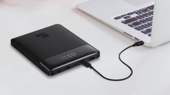
Best Power Banks with Power Delivery for Charging LaptopsCapacious batteries with support for fast charging Power Delivery, which are capable of charging laptops.
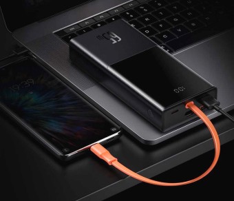
Best 20,000 mAh Power Banks with Fast ChargingPower banks that will quickly and recharge your mobile devices.
How to place an order?How to add store?
Remember that the online store is responsible for the accuracy of information regarding price, warranty, and delivery!
We recommendCompare using chart →
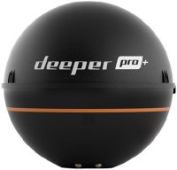
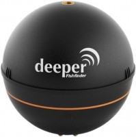
fish finder, up to 80 m, radiation: 70 °, frequencies: 2, rays: 2, wireless sensor, Wi-Fi
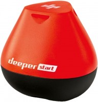
fish finder, up to 50 m, radiation: 40 °, frequencies: 1, rays: 1, wireless sensor, Wi-Fi
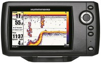
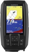
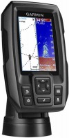
fish finder-chartplotter, colour, up to 1524 m, radiation: 120 °, frequencies: 6, rays: 2, GPS
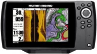
fish finder-chartplotter, colour, up to 274 m, frequencies: 6, rays: 3, GPS, 3D maps, Wi-Fi
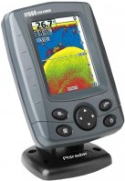
fish finder-chartplotter, colour, up to 450 m, radiation: 180 °, frequencies: 3, rays: 2, GPS

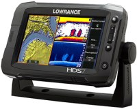
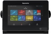
fish finder-chartplotter, colour, up to 1524 m, radiation: 180 °, frequencies: 5, rays: 6, GPS, Wi-Fi
fish finder-chartplotter, colour, up to 580 m, radiation: 120 °, frequencies: 3, rays: 2, GPS