Map coverage
The region of the world for which map data is available on your navigation device. Map coverage determines which geographic areas and countries can be displayed and used for navigation on a specific device. Note that coverage may vary in detail and content: some preset maps may contain detailed information about roads, landmarks, shops, gas stations and the like on a global scale, while others are often limited to the basic road network for a particular country or region .
To make it easier to find a suitable solution for map coverage, registrars can be divided into several subcategories based on territoriality:
Europe,
Africa,
the whole world.
Lifetime map updates
Availability
of life-long updating of maps in this model of the navigator.
When buying a navigator with this feature, the user also acquires a subscription to map updates supplied in the kit. Such a subscription, in fact, is perpetual: updates are available all the time while the navigator is generally working. Thus, this service allows you to always have the latest maps at your disposal. It is found mainly in automotive and motorcycle models: it is for these areas of application that regular updates are most relevant, since traffic conditions can change very quickly. However note that the cost of subscribing to updates is included in the price of the device and affects it, sometimes quite noticeably.
Navigation functions (assistants)
Special navigation functions provided in the device.
—
Speed limit. A function that allows you to use the navigator to obtain information about the speed limit on a particular road. Most often, the speed limit is used in the operational prompt mode: the device warns the driver in advance about approaching a section of the road where the speed limit differs from the current one, and also issues a warning if the driver accelerates above the permissible limit. This can prevent not only an unpleasant conversation with the traffic police, but also a serious accident.
—
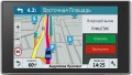
Traffic jams in real time. A function that allows the driver to see real-time traffic data on the device screen. As a rule, models with a traffic monitoring function provide detailed information about the volume of traffic in general. Moreover, this information is monitored and updated constantly, in real time, and is immediately taken into account by the navigator - to the point that if difficulties arise on a pre-planned route, the device can automatically reroute it to avoid congestion. At the same time, it is worth considering that real-time traffic data is usually transmitted through the TMC network (see “TMC receiver”), and it is not available everywhere.
—
GPS informant. A function to provide the driver with various useful information related to the current location. In acc
...ordance with the name, the coordinates are determined using GPS. One of the most common ways to use an informant is to warn about approaching traffic cameras, stationary traffic police posts and speed control systems. In addition, other functions may be provided - for example, informing about entering a section of the road with a high accident rate or a separate large hole on the roadway. To operate the GPS informer, a database of relevant objects is entered into the device’s memory. When purchasing a navigator, it doesn’t hurt to clarify what exactly this database contains, how recent it is, and whether it can be updated.
— Lane selection. A function that provides the driver with hints regarding lane selection. Such tips make driving more convenient and safe: the navigator warns the driver in advance about the need to change lanes for a turn/turn (or vice versa, in order to drive straight past the turn). This allows you to avoid “misses” on the road and emergency lane changes, which often create emergency situations. This function is especially relevant for complex interchanges on multi-lane highways.
— Parking in real time. As its name suggests, this feature allows you to determine if there are nearby parking options for your vehicle. In addition, navigators that support the real-time parking function are also capable of displaying various auxiliary information, for example, type of parking, parking cost, payment methods, etc.
— The way back. The function of using a record of the distance traveled as a route to return from the finish point to the start point. Thanks to it, the customer can go back the same way he got to the current point. This opportunity is especially important in conditions of difficult terrain and the absence of roads - for example, during hiking trips or off-road jeep trips: returning along an already explored path is often easier and safer than looking for a new route. Actually, the opposite way is found mainly among universal pocket navigators (see “Scope of Application”), although there are exceptions - for example, the same car models.
- “Where am I?”. A function that helps the customer determine their current location. At the same time, we are talking not only about a point on the map and geographic coordinates - in addition to this data, the navigator, when you turn on the “Where am I?” function. displays various additional information: the address of the nearest building, information about the nearest intersection, nearby important objects (gas stations, hospitals, police stations, etc.).
— Prices at gas stations in real time. A function that provides information about current fuel prices at various gas stations along your travel route. It can be useful for drivers, as it allows them to find the most profitable or nearest gas stations to refuel and save money.
— Weather in real time. A feature that allows the navigator to receive real-time weather data. This can be either information about current weather conditions in a particular place on the map, or a forecast for a certain period. In addition to basic weather information (temperature, fit, wind, humidity, fog, etc.), this service can support advanced data such as storm warnings, flood or landslide reports. The necessary data can arrive in different ways - most often through a satellite or a special radio channel. These details should be clarified separately.
- Supervision of children. A function that allows the driver to use the navigator screen to observe the rear seat of the car without turning around and without being distracted from the road. Most often it is used to monitor a child who is in the back seat. Of course, to use the child monitoring function you will need not only a navigator, but also a camera compatible with it.DAB receiver
The presence
of a DAB receiver in the design of the navigator.
The abbreviation DAB stands for Digital Broadcasting. This is the key difference between this standard and other popular formats (including FM known to many): the radio signal during such broadcasting is transmitted in digital form, using the MP2 codec.
Digital broadcasting has a number of advantages over analogue broadcasting. So, in a similar way, you can achieve a greater range with a lower power of transmitters, and without loss in quality. Actually, the sound quality in DAB does not depend on the strength of the received signal; to be more precise, weak interference does not affect its quality, and if the power drops to a critical level, the sound is not distorted, but disappears completely. The disadvantage of this standard is its relatively low prevalence; therefore, before buying a navigator with DAB, it is worth checking whether there is a digital broadcast in your area and what are the technical requirements for receivers for such broadcasting.
TMC receiver
The presence
of a TMC receiver in the design of the navigator.
TMC (Traffic Message Channel) is a technology for transmitting information about adverse traffic situations — traffic jams, accidents, weather conditions, etc. Transmissions are most often carried out in the FM band, similar to conventional radio broadcasting; therefore, you do not need to access the Internet to obtain important traffic information, although some TMC services may be chargeable.
It is worth bearing in mind that a network of appropriate stations is required to use TMC. Such networks exist in many European countries, but their development in the post-Soviet space began relatively recently. Therefore, before buying a navigator with this function, you need to check whether TMC coverage is available in your area.