Pre-installed soft
The navigation programme, originally installed in the navigator and sold with it, in other words, a set of maps available to the user “out of the box”.
Most modern navigators are equipped with such programs (although the name of pre-installed maps is not indicated for all models). Note that the functionality of complete programs in different models may vary. Most often, these are the simplest maps of the world or the region in which this device is sold. However, there are exceptions: there are models with detailed maps, programs with advanced functionality, etc. Such exceptions are especially common among high-end specialized devices, in particular marine and aviation (see "Scope"). And for some navigators, there may be several options for pre-installed programs and even the ability to select such programs at the request of the user. All these details should be specified in each case according to the manufacturer or seller.
It is also worth considering that the characteristics often indicate only the general name of the cards. At the same time, the same card can be available in several versions that differ in functionality and, sometimes, terms of use (paid / free). However, the main features are basic capabilities, interface device, etc. — usually, are common to all versions. Therefore, by the name of the complete programme, usually, one can quite accurately determine the general capabilities and features of the card's functionality.
Lifetime map updates
Availability
of life-long updating of maps in this model of the navigator.
When buying a navigator with this feature, the user also acquires a subscription to map updates supplied in the kit. Such a subscription, in fact, is perpetual: updates are available all the time while the navigator is generally working. Thus, this service allows you to always have the latest maps at your disposal. It is found mainly in automotive and motorcycle models: it is for these areas of application that regular updates are most relevant, since traffic conditions can change very quickly. However note that the cost of subscribing to updates is included in the price of the device and affects it, sometimes quite noticeably.
Navigation functions (assistants)
Special navigation functions provided in the device.
—
Speed limit. A function that allows you to use the navigator to obtain information about the speed limit on a particular road. Most often, the speed limit is used in the operational prompt mode: the device warns the driver in advance about approaching a section of the road where the speed limit differs from the current one, and also issues a warning if the driver accelerates above the permissible limit. This can prevent not only an unpleasant conversation with the traffic police, but also a serious accident.
—
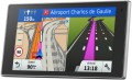
Traffic jams in real time. A function that allows the driver to see real-time traffic data on the device screen. As a rule, models with a traffic monitoring function provide detailed information about the volume of traffic in general. Moreover, this information is monitored and updated constantly, in real time, and is immediately taken into account by the navigator - to the point that if difficulties arise on a pre-planned route, the device can automatically reroute it to avoid congestion. At the same time, it is worth considering that real-time traffic data is usually transmitted through the TMC network (see “TMC receiver”), and it is not available everywhere.
—
GPS informant. A function to provide the driver with various useful information related to the current location. In acc
...ordance with the name, the coordinates are determined using GPS. One of the most common ways to use an informant is to warn about approaching traffic cameras, stationary traffic police posts and speed control systems. In addition, other functions may be provided - for example, informing about entering a section of the road with a high accident rate or a separate large hole on the roadway. To operate the GPS informer, a database of relevant objects is entered into the device’s memory. When purchasing a navigator, it doesn’t hurt to clarify what exactly this database contains, how recent it is, and whether it can be updated.
— Lane selection. A function that provides the driver with hints regarding lane selection. Such tips make driving more convenient and safe: the navigator warns the driver in advance about the need to change lanes for a turn/turn (or vice versa, in order to drive straight past the turn). This allows you to avoid “misses” on the road and emergency lane changes, which often create emergency situations. This function is especially relevant for complex interchanges on multi-lane highways.
— Parking in real time. As its name suggests, this feature allows you to determine if there are nearby parking options for your vehicle. In addition, navigators that support the real-time parking function are also capable of displaying various auxiliary information, for example, type of parking, parking cost, payment methods, etc.
— The way back. The function of using a record of the distance traveled as a route to return from the finish point to the start point. Thanks to it, the customer can go back the same way he got to the current point. This opportunity is especially important in conditions of difficult terrain and the absence of roads - for example, during hiking trips or off-road jeep trips: returning along an already explored path is often easier and safer than looking for a new route. Actually, the opposite way is found mainly among universal pocket navigators (see “Scope of Application”), although there are exceptions - for example, the same car models.
- “Where am I?”. A function that helps the customer determine their current location. At the same time, we are talking not only about a point on the map and geographic coordinates - in addition to this data, the navigator, when you turn on the “Where am I?” function. displays various additional information: the address of the nearest building, information about the nearest intersection, nearby important objects (gas stations, hospitals, police stations, etc.).
— Prices at gas stations in real time. A function that provides information about current fuel prices at various gas stations along your travel route. It can be useful for drivers, as it allows them to find the most profitable or nearest gas stations to refuel and save money.
— Weather in real time. A feature that allows the navigator to receive real-time weather data. This can be either information about current weather conditions in a particular place on the map, or a forecast for a certain period. In addition to basic weather information (temperature, fit, wind, humidity, fog, etc.), this service can support advanced data such as storm warnings, flood or landslide reports. The necessary data can arrive in different ways - most often through a satellite or a special radio channel. These details should be clarified separately.
- Supervision of children. A function that allows the driver to use the navigator screen to observe the rear seat of the car without turning around and without being distracted from the road. Most often it is used to monitor a child who is in the back seat. Of course, to use the child monitoring function you will need not only a navigator, but also a camera compatible with it.TMC receiver
The presence
of a TMC receiver in the design of the navigator.
TMC (Traffic Message Channel) is a technology for transmitting information about adverse traffic situations — traffic jams, accidents, weather conditions, etc. Transmissions are most often carried out in the FM band, similar to conventional radio broadcasting; therefore, you do not need to access the Internet to obtain important traffic information, although some TMC services may be chargeable.
It is worth bearing in mind that a network of appropriate stations is required to use TMC. Such networks exist in many European countries, but their development in the post-Soviet space began relatively recently. Therefore, before buying a navigator with this function, you need to check whether TMC coverage is available in your area.
Display
Parameters of the display installed in the navigator.
— Display diagonal. Size screen size in inches. The larger the screen, the more information can be displayed on it and the more detailed this information will be presented. On the other hand, the size of the display significantly affects the dimensions of the device, and large screens are more expensive.
— Display resolution. Display size in dots (pixels) horizontally and vertically. The higher the resolution (with the same diagonal), the more detailed and clear the image the screen can produce. In addition, on high-resolution displays, small details are better visible, which increases the comfort of viewing information. Too high a resolution is usually not required for GPS navigator displays: for example, 800x480 pixels, limited by the standards of smartphones or tablets, with a diagonal screen size of about 6” are considered quite sufficient even for an advanced device.
— Matrix type. This parameter is indicated mainly for tech cases when the screen uses a high-quality
IPS type matrix. This technology provides high quality color rendering, good brightness and wide viewing angles; moreover, IPS screens are relatively inexpensive to produce.
- Touch. Screen support for touch control. You can give commands to the device by touching the icons on the display itself - similar to how this is done in smartphones and tablets. Touch control opens up
...many more possibilities than classic controls and provides flexibility in working with the navigator. In particular, by touching the screen you can set points on the route, zoom in or out on the map, etc.
- Color. This parameter determines whether the screen is color or monochrome (black and white). Black and white displays are simple, inexpensive, consume little power, and are quite suitable for displaying basic navigation information. At the same time, color screens are more functional: maps often use different colors to highlight individual objects, which would not be possible on monochrome displays. As a result, black and white screens are quite rare among modern navigators - mainly among the most compact and inexpensive models.
— Backlight. The screen has its own backlight system. This function makes the device independent of external lighting: the illuminated image will be normally visible both at dusk and even in complete darkness. It is also worth noting that many LCD screens have a backlight by default; it is activated when the screen itself is turned on and works regardless of external lighting - without it, the image on the matrix would simply be impossible to see. In particular, this operating principle is used in IPS-type matrices, which have gained popularity in modern portable electronics (including navigators).Battery life
The operating time of the navigator on one battery charge or a set of batteries depends on the power source (see above).
This parameter is more visual and closer to reality than technical information about the type of batteries, battery capacity, etc. However note that the operating time is usually indicated for a conditional perfect situation: a good signal level without the need to reconnect, low screen brightness ( or completely turned off the backlight), minimal use of wireless modules (Wi-Fi, Bluetooth), etc. Practical conditions inevitably differ from perfect — accordingly, the operating time may differ noticeably from the claimed one (usually in the direction of reduction, but sometimes vice versa) . Nevertheless, the operating time stated in the characteristics is quite reliable information, and it is quite possible to evaluate the capabilities of the selected device, as well as compare it with other models.