
Fish Finders
prices on 591 modelShow
When you make a purchase through links on our site, we may receive a affiliate commission.
 | A comprehensive, all-in-one solution, Navionics+ charts and maps combine clear, reliable coastal/inland content with advanced guidance features and compatibility with a wide range of chartplotter brands.Features:- Navigate with our best offshore and inland lake coverage for your compatible chartplotter.- See it your way. Customise your view with various chart layers and overlay combinations.- With your included 1-year subscription, access daily updates via the Navionics® chart installer software.- Advanced route guidance technology lets you navigate with suggested dock-to-dock routings.- Selectable map options let you highlight shallow areas, adjust contour density or select a fishing range.-… |  |
 | GARMIN NAEU643L Mediterranean & Black Sea Navionics®+ Micro SD/SD Card MapCategory: ElectronicsSubcatego | |
 | Garmin NAEU628L Navionics+ U.K./Ireland & Holland Map CardCategory: ElectronicsSubcatego | |
 | GARMIN NAEU066R Alpine/Lakes&Rivers Navionics®+ Micro SD/SD Card MapUnlock unparalleled detail and navigational confidence on Europe´s stunning inland waterways with the Garmin NAEU066R Navionics®+ cartography card. Specifically designed for the Alpine region´s lakes and rivers, this all-in-one solution provides the most comprehensive and up-to-date mapping data available, transforming your compatible chartplotter into a powerful navigation tool for safer and more successful journeys.Experience the difference with the world-renowned Navionics+ data suite. Get the world's No. 1 choice in marine mapping¹ — with the best, most up-to-date Navionics®+ cartography on your compatible chartplotter². For offs… | |
 | Refurbished reasons: Open box item with packaging showing minor imperfections. Get a great deal on this carefully inspected open-box product, offering premium navigation features at a reduced price. Ideal for boaters looking for reliable chart data while enjoying excellent value.GARMIN NAEU010R Spain/Mediterranean Coast Navionics®+ Micro SD/SD Card MapCategory: ElectronicsSubcatego | |
You may be interested in
 | GARMIN NAEU010R Spain/Mediterranean Coast Navionics®+ Micro SD/SD Card MapCategory: ElectronicsSubcatego | |
 | GARMIN NAEU009R Portugal&Spain/North | |
 | Bluechart G3 Coastal Charts Provide Industry-Leading Coverage, Clarity And Detail With Integrated Garmin And Navionics Data. Also Included Is Auto Guidance1 Technology, Which Uses Your Desired Depth And Overhead Clearance To Calculate Routes And Provide A Suggested Path To Follow — Overlaid Onto Your Chart. Noaa Raster Cartography Is Also Available As A Free Downloadable Feature Via The Activecaptain App. It Gives Your Chartplotter Paper Chartlike Views Of Noaa-Surveyed Areas In Which Individual Points Of Interest Are Labeled With Corresponding Longitude And Latitude Information. Worldwide Coverage Is Available By Regions As Accessory Cards Or Via Download, Each Region Is Sold Separately.Features: | |
 | GARMIN NAAF004R Navionics®+ Marine Charts | Premium Cartography for Northwest AfricaCategory: ElectronicsSubcatego | |
 | Your purchase includes charts, maps and any content downloaded during the one-year subscription period. An active subscription is required to continue accessing new content such as daily updates after the included one-year ends.Verify that your device is compatible. If your device is not compatible, you can still purchase g3 charts.It´s whole new look on your Chartplotter:- Featuring vibrant colors, a streamlined interface and combined coastal/inland content with a popular Navionics® style color palette, Garmin Navionics+ cartography makes it easy to plot your course with the world's No. 1 name in marine mapping1.- Navigate with our best offshore and inland lake coverage for your Garmin chartplotter.- … | |
 | A comprehensive, all-in-one solution, Navionics+ charts and maps combine clear, reliable coastal/inland content with advanced guidance features and compatibility with a wide range of chartplotter brands.Navigate with our best offshore and inland lake coverage for your compatible chartplotter1.See it your way.Customize your view with various chart layers and overlay combinations.With your included 1-year subscription, access daily updates via the Navionics® chart installer software.Advanced route guidance technology2 lets you navigate with suggested dock-to-dock routings.Selectable map options let you highlight shallow areas, adjust contour density or select a fishing range.Save money — while con… | |
 | Featuring vibrant colors, a streamlined interface and combined coastal/inland content with a popular Navionics® style color palette, Garmin Navionics+ cartography makes it easy to plot your course with the world´s No.1 name in marine mapping1.Navigate with our best offshore and inland lake coverage for your Garmin chartplotter.See it your way.Customize your view with various chart layers and overlay combinations.With your included one-year subscription, access daily updates via the ActiveCaptain® smart-device app.Auto Guidance+™ technology2 lets you navigate with suggested dock-to-dock routings.Select up to 10 color-shaded target depth ranges to scope out the best fishing spots.Save money by re… | |




 | It's A Whole New Look On Your Chartplotter:- Featuring vibrant colors, a streamlined interface and combined coastal/inland content with a popular Navionics® style color palette, Garmin Navionics+ cartography makes it easy to plot your course with the world's No. 1 name in marine mapping.- Navigate with our best offshore and inland lake coverage for your Garmin chartplotter.- See it your way. Customize your view with various chart layers and overlay combinations.- With your included one-year subscription, access daily updates via the ActiveCaptain® smart-device app.- Auto Guidance+™ technology2 lets you navigate with suggested dock-to-dock routings.- Select up to 10 color-shaded target depth rang… | |
 | A comprehensive, all-in-one solution, Navionics+ charts and maps combine clear, reliable coastal/inland content with advanced guidance features and compatibility with a wide range of chartplotter brands.- Navigate with our best offshore and inland lake coverage for your compatible chartplotter.- See it your way. Customize your view with various chart layers and overlay combinations.- With your included 1-year subscription, access daily updates via the Navionics® chart installer software.- Advanced route guidance technology2 lets you navigate with suggested dock-to-dock routings.- Selectable map options let you highlight shallow areas, adjust contour density or select a fishing range.- Save m… | |
 | Featuring vibrant colors, a streamlined interface and combined coastal/inland content with a popular Navionics® style color palette, Garmin Navionics+ cartography makes it easy to plot your course with the world's No. 1 name in marine mapping1.Features:- Navigate with our best offshore and inland lake coverage for your Garmin chartplotter.- See it your way. Customize your view with various chart layers and overlay combinations.- With your included one-year subscription, access daily updates via the ActiveCaptain® smart device app.- Auto Guidance+™ technology1 lets you navigate with suggested dock-to-dock routings.- Select up to 10 color-shaded target depth ranges to scope out the best fishing spot… | |
 | GARMIN Mar Tirreno Regular Marine Charts - VEU012R | Ultimate Navigation for the Tyrrhenian SeaUnlock a new level of confidence and precision on the water with the GARMIN Mar Tirreno Regular Marine Charts. Specifically designed for sailors, anglers, and powerboaters navigating the beautiful but complex waters of the Tyrrhenian Sea, this advanced cartography from the Electronics and Cartography category transforms your compatible Garmin chartplotter into an indispensable navigation partner. Experience the Mediterranean like never before, with rich detail and intelligent features that guide your every journey, ensuring safety and enhancing your time on the sea.Revolutionary Auto Guidance TechnologyNavigate … | |
 | Reel in the Big One with the LUCKY Manual Wireless Fish Finder!Looking for a powerful yet affordable way to up your fishing game? Look no further than the LUCKY Manual Wireless Fish Finder! This compact device packs a punch, delivering accurate depth readings and fish location data directly to your smartphone or tablet, turning your personal device into a dynamic fish-finding hub. Unleash the Power of Wireless: Ditch the tangled cords and bulky screens with the LUCKY Fish Finder´s seamless wireless connectivity. The transducer casts out up to 120 feet, transmitting sonar data directly to your device via a dedicated app, available for both iOS and Android. Pinpoint Your Prey: Never waste time g… | |
 | Garmin BlueChart g3 Vision VEU011R – Ligurian Sea, Corsica & Sardinia | Detailed Mediterranean Marine CartographyNavigate the stunning and historic waters of the Mediterranean with unparalleled confidence and detail. The Garmin BlueChart g3 Vision VEU011R marine chart provides the ultimate cartography solution for mariners exploring the breathtaking coastlines of the Ligurian Sea, Corsica, and Sardinia. By seamlessly integrating the best of both Garmin and Navionics® data, this advanced chart offers an unmatched level of accuracy, coverage, and innovative features, transforming your compatible Garmin chartplotter into a powerful navigational tool. Whether you are cruising from Genoa to the Tus… | |
 | The RAYMARINE LightHouse SD 32Gb Preloaded Western Europe Chart is an essential electronic device for seafarers and boating enthusiasts. It is designed to provide detailed and accurate cartographic information of the Western European coastlines, making navigation effortless and safe.This chart card comes with a storage capacity of 32Gb, providing ample space for storing a large amount of data including marine charts, maps, and other navigation tools. The preloaded Western Europe chart ensures that users have immediate access to vital information without the need for additional downloads or updates.Featuring multicolored graphics, this chart card offers enhanced visibility and easy interpretation … | |
 | The RAYMARINE LightHouse SD 32Gb Preloaded Northern Europe Chart Multicolour is a cutting-edge electronic cartography device designed specifically for marine navigational purposes. This compact and convenient tool incorporates a preloaded SD card with a storage capacity of 32 gigabytes, offering ample space to store an extensive range of Northern European charts.Featuring a multicolour display, the LightHouse SD provides a visually intuitive experience, allowing sailors, fishermen, and other maritime enthusiasts to accurately and effortlessly assess their location, plan routes, and navigate through intricate waterways. The vibrant colours and clear imagery enhance the user's ability to distinguish … | |
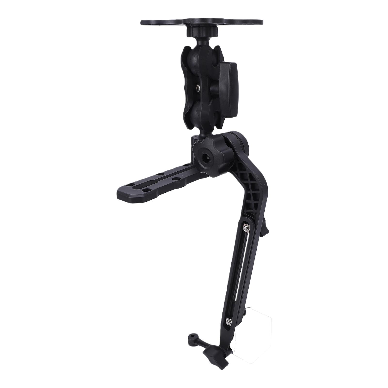 | Feature: 1. 360 degrees ADJUSTABLE MOUNT: Featuring a 360 degrees adjustable bracket with 1.5 inch ball base that provides 18lbs (approx. 8.2 kilograms) of clamping force, allowing smooth 360 degrees rotation of the screen. 2. WIDE COMPATIBILITY: Designed specifically fit for Striker 4, fit for Striker Plus 4, fit for Striker Vivid 4cv, fit for ECHOMAP Plus 43cv 44cv series, also applicable to fit for Lowrance Elite Hook series and fit for Humminbird Helix 5 types. 3. MARINE GRADE STRUCTURE: Constructed with high strength composite material base and hardware, offering 5 times durability compared to regular plastic brackets in harsh water environments. Anti slip rubber coating prevents GPS devices … |  |
 | Introducing the GARMIN Italy Lakes&Rivers Navionics Vision+™ Marine Charts, the ultimate map solution for your Garmin chartplotter. With vibrant colors, a streamlined interface, and combined coastal/inland content, this cartography is designed to make navigation easy and efficient. As the world´s No. 1 name in marine mapping, Garmin Navionics+ offers the best offshore and inland lake coverage for Western Europe.Customize your view with various chart layers and overlay combinations, allowing you to see it your way. With your included one-year subscription, you can access daily updates via the ActiveCaptain® smart device app, ensuring that your charts are constantly enhanced with new and amended cont… | |
 | Featuring vibrant colors, a streamlined interface and combined coastal/inland content with a popular Navionics® style color palette, Garmin Navionics+ cartography makes it easy to plot your course with the world´s No.1 name in marine mapping1.Navigate with our best offshore and inland lake coverage for your Garmin chartplotter.See it your way.Customize your view with various chart layers and overlay combinations.With your included one-year subscription, access daily updates via the ActiveCaptain® smart-device app.Auto Guidance+™ technology2 lets you navigate with suggested dock-to-dock routings.Select up to 10 color-shaded target depth ranges to scope out the best fishing spots.Save money by re… | |
 | Featuring vibrant colors, a streamlined interface and combined coastal/inland content with a popular Navionics® style color palette, Garmin Navionics+ cartography makes it easy to plot your course with the world´s No.1 name in marine mapping1.Navigate with our best offshore and inland lake coverage for your Garmin chartplotter.See it your way.Customize your view with various chart layers and overlay combinations.With your included one-year subscription, access daily updates via the ActiveCaptain® smart-device app.Auto Guidance+™ technology2 lets you navigate with suggested dock-to-dock routings.Select up to 10 color-shaded target depth ranges to scope out the best fishing spots.Save money by re… | |
24 more item(s)
